


T-ori-JG-A53S-25-Bosses

Jack-94
User
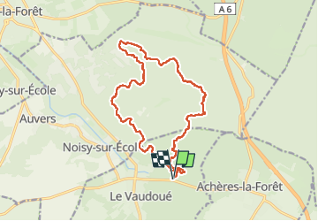

Length
16.9 km

Max alt
122 m

Uphill gradient
433 m
Km-Effort
23 km

Min alt
71 m

Downhill gradient
433 m
Boucle
Yes
Creation date :
2024-05-25 07:03:20.043
Updated on :
2024-06-21 17:32:46.261
9h38
Difficulty : Very difficult

FREE GPS app for hiking
 SityTrail
IGN / Geographical institutes
SityTrail Plus
The world is yours!
About
Trail Walking of 16.9 km to be discovered at Ile-de-France, Seine-et-Marne, Le Vaudoué. This trail is proposed by Jack-94.
Positioning
Country:
France
Region :
Ile-de-France
Department/Province :
Seine-et-Marne
Municipality :
Le Vaudoué
Location:
Unknown
Start:(Dec)
Start:(UTM)
465512 ; 5356353 (31U) N.
Comments